Discovering Los Angeles Oilfields

Natural oil seeps, giant oilfields, and the beginning of the California petroleum industry.


“Everyone thinks of Los Angeles as the ultimate car city, but the city’s relationship with petroleum products is far more significant than just consumption.” — Center for Land Use Interpretation

When struggling prospector Edward L. Doheny and his mining partner Charles Canfield decided to dig a well in 1892, they chose a site already known for its “tar” pools that bubbled to the surface. (more…)

Anadarko Basin in Depth

Giant rigs drilled to record depths in Oklahoma in the 1970s.


The Anadarko Basin, extending more than 50,000 square miles across west-central Oklahoma and the Texas Panhandle, includes some of the most prolific natural gas reserves in the United States — and a 1974 drilling record.

Beginning in the late 1950s, when technological advances allowed it, Anadarko Basin wells in Oklahoma began to be drilled more than two miles deep in search of highly pressurized natural gas zones. (more…)

Central Oil Shale Refining Company

Chicago business sought risky shale opportunities during WWI.


At the end of the 20th century, record-breaking petroleum production from shale oil grew thanks to drilling and production technologies that produced from low permeability “tight oil” formations. But a century ago, the shale was an unconventional resource mined, crushed and transported to a retorting facility.

Mining shale began as an extraction process that converted organic matter within the rock (kerogen) into synthetic oil and gas, which could be used as a fuel or upgraded for an oil refinery feedstock.

The strategic importance of America’s mined shale production led to establishment of the Naval Petroleum and Oil Shale Reserves in 1912, “to insulate the United States from foreign dependency on oil during times of war.”

Commissioned in 1914 with coal-powered boilers, the battleship USS Texas was converted to use fuel oil in 1925. Photo courtesy Texas Parks and Wildlife Department.

Commissioned in 1914 with coal-powered boilers, the battleship USS Texas was converted to use fuel oil in 1925. Photo courtesy Texas Parks and Wildlife Department.

Meanwhile, fuel oil also began replacing coal in U.S. warships (See Petroleum and Sea Power), as World War I erupted in Europe. After more than three years of neutrality, America entered the war on April 2, 1917.

Recognizing wartime demand for oil, Van H. Manning, director, U.S. Bureau of Mines, declared, “We have as yet untouched our great reserves of shale that contain oil…and are conservatively estimated to contain many times the amount of oil that has been or will have been produced from all the porous formations in this country.”

Support the American Oil & Gas Historical Society

Central Oil Shale Refining Company formed with $500,000 capitalization and set up offices in Chicago. The venture saw a financial opportunity in mining shale and secured leases on 480 acres in Garfield County, Colorado, an area with known deposits.

Central Oil Shale Refining also leased a total of about 5,000 acres in Kentucky, Kansas, and Texas. These investments were a gamble on the margins of supply and demand.

Despite the risks, Central Oil Shale Refining presented “Expert Information on Oil Shale” to stockholders and potential investors at Chicago’s Palmer House hotel. Company executives promoted the mining and distillation of Colorado oil shales as an opportunity not to be missed. It helped that publications like Oil Field Engineering (December 1917) proclaimed shales as “A New Source of Gasoline.”

Shale Business Model

Oil shale operator Joseph Bellis presented a business model to the Palmer House audience, describing oil shale production process and economics. Bellis, a veteran of Colorado shale mining in the Piceance Creek Basin, later published a paper in the Colorado School of Mines’ quarterly magazine.

The paper may have helped Central Oil Shale Refining stock sales, but the company’s trajectory had already been determined on a farm near Ranger, Texas.

Concerns about U.S. wartime oil supplies declined — along with oil prices — soon after an October 17, 1917, gusher halfway between Abilene and Dallas. Still annually celebrated by area residents, “Roaring Ranger” J. McCleskey No. 1 well produced 1,600 barrels of oil a day. Other wells in the oilfield would yield up to 10,000 barrels of oil daily.

The North Texas drilling boom opened giant fields near Desdemona and Breckenridge (Conrad Hilton would buy his first hotel in Cisco). An even bigger oilfield was found in 1918 at Burkburnett, near Wichita Falls. With suddenly abundant supplies, oil sold for less than $2 per barrel — five cents a gallon.

Support the American Oil & Gas Historical Society

Central Oil Shale Refining was in deep trouble. Even if every ton mined resulted in 50 gallons of oil, it would take more than 1,300 tons of shale every day to match the McCleskey’s well production alone. The numbers didn’t work and debts needed to be paid.

In one last effort to survive, Central Oil Shale Refining reorganized with the same officers, moved its offices, and subtly changed its name to Central Oil Shale and Refining Company. The new company quickly failed, leaving a brief shadow in financial records.

Another example of producing commercial quantities of petroleum from shale can be found in Ute Oil Company – Oil Shale Pioneer. By the 1980s, new technologies revolutionized petroleum production from low-permeability shales — especially for natural gas.

U.S. crude oil production chart. Annual U.S. crude oil production reached a record level of 10.96 million barrels per day in 2018, according to the U.S. Energy Information Administration.

Annual U.S. crude oil production reached a record level of 10.96 million barrels per day in 2018, according to the U.S. Energy Information Administration.

Although geologists had known of the potential of drilling in these “tight oil” formations, only one percent of U.S. natural gas production came from shale as late as 2000. But by applying horizontal drilling and hydraulic fracturing techniques, in 2010 shale gas accounted for more than 20 percent of U.S. natural gas production, according to the Energy Information Administration (EIA).

_______________________

The American Oil & Gas Historical Society (AOGHS) preserves U.S. petroleum history. Become an AOGHS annual supporting member and help maintain this energy education website and expand historical research. For more information, contact bawells@aoghs.org. © 2024 Bruce A. Wells.

Citation Information – Article Title: “Central Oil Shale Refining Company.” Authors: B.A. Wells and K.L. Wells. Website Name: American Oil & Gas Historical Society. URL: https:https://aoghs.org/old-oil-stocks/central-oil-shale-refining-company. Last Updated: March 31, 2024. Original Published Date: April 1, 2019.

Rigs to Reefs

Thousands of offshore petroleum structures provide energy — and marine habitats.


Offshore petroleum platforms act as artificial reefs, creating important marine habitats, according to scientists. Beginning with an Exxon experimental subsea structure in 1979, the U.S. government’s “Rigs to Reefs” program established the largest artificial habitat in the world.

The Gulf of Mexico, both onshore and offshore, has continued to be a key contributor to U.S. oil and natural gas resources and energy infrastructure. Federal offshore oil production in 2023 accounted for 15 percent of total U.S. crude oil and five percent of natural gas production, according to the U.S. Energy Information Administration (EIA).  

Diver swims between pylons of offshore oil platform.

Offshore platforms make good artificial reefs. The open design attracts fish — and divers — where they can swim easily through the circulating water. Photo courtesy U.S. Bureau of Safety and Environmental Enforcement.

(more…)

THUMS – California’s Hidden Oil Islands

Reversing an earlier ban, voters in Long Beach, California, in 1962 approved petroleum exploration in their harbor. Five major oil companies formed a company called THUMS and built four artificial islands to produce the oil.

California’s headline-making 1921 oil discovery at Signal Hill launched a drilling boom that transformed the quiet residential area. So many derricks sprouted it became known as “Porcupine Hill.”
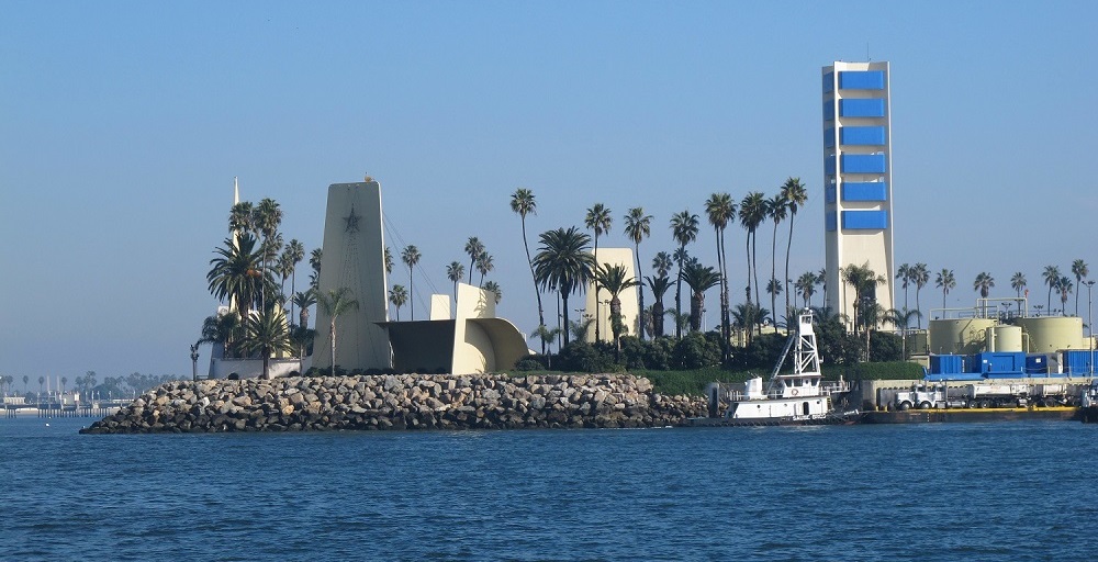
One of the California THUMS islands hidden oil derricks in landscaped setting.

Island Grissom, one of the four THUMS islands at Long Beach, California, was named after NASA astronaut Col. Virgil “Gus” Grissom, who died in 1967 in the Apollo spacecraft fire. Photo courtesy U.S. Department of Energy.

With many homeowners aspiring to become drillers and oilfield speculators, much of Signal Hill’s land was sold and subdivided in real estate lots of a size described as “big enough to raise chickens.”

Derricks were so close to one cemetery that graves “generated royalty checks to next-of-kin when oil was drawn from beneath family plots,” noted one historian. Neighboring Long Beach joined the drilling boom.

Support the American Oil & Gas Historical Society

By 1923, oil production reached more than one-quarter million barrels of oil per day. When Long Beach instituted a per-barrel oil tax, Signal Hill residents voted to incorporate in 1924.

At the time, “the law of capture” for petroleum production ensured the formerly scenic landscape would be transformed. Competing exploration and production companies crowded around newly completed wells and chased any signs of oil to the Pacific Ocean.
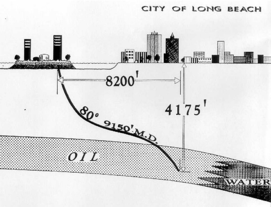
THUMS island illustration of oil reservoir beneath Long Beach

The islands are among the most innovative oilfield designs in the world. Circa 1965 illustration courtesy Oxy Petroleum.

By the early 1930s, the massive Wilmington oilfield extended through Long Beach as reservoir management concerns remained in the future. Naturally produced California oil seeps had led to many discoveries south of the 1892 Los Angeles City field.

Onshore and offshore tax revenues generated by production of more than one billion barrels of oil and one trillion cubic feet of natural gas helped underwrite much of the Los Angeles area’s economic growth. But not without consequences.

Long Beach: A Sinking City

The U.S. Army Corps of Engineers reported, “Subsidence, the sinking of the ground surface, is typically caused by extracting fluids from the subsurface.”

Long Beach CA oil derricks circa 1923 panorama.

Petroleum reserves brought drilling booms to southern California. By 1923, oil production reached more than one-quarter million barrels of oil per day from Signal Hill, seen in the distance in this detail from a panorama from the Library of Congress.

Californians had a lot  of experience dealing with groundwater induced subsidence and the building damage it caused, but by 1951, Long Beach was sinking at the alarming rate of about two feet each year.

Earth scientists noted that between 1928 and 1965, the community sank almost 30 feet. TIME magazine call the bustling port “America’s Sinking City.”

Support the American Oil & Gas Historical Society

After decades of prospering from petroleum production, the city prohibited “offshore area” drilling to slow the subsidence as the community looked for a solution.

On February 27, 1962, Long Beach voters approved “controlled exploration and exploitation of the oil and gas reserves” underlying their harbor. The city’s charter had prohibited such drilling since a 1956 referendum. Advancements in oilfield technologies enabled Long Beach to stay afloat.

Directional drilling and water injection opened another 6,500 acres of the Wilmington field — and saved the sinking city.

THUMS: Texaco, Humble, Union and Shell

Five oil companies formed a Long Beach company called THUMS: Texaco (now Chevron), Humble (now ExxonMobil), Union Oil (now Chevron), Mobil (now ExxonMobil) and Shell Oil Company. They built four artificial islands at a cost of $22 million in 1965 (more than $200 in 2024 dollars).

The islands — named in 1967 Grissom, White, Chaffee, and Freemen in honor of lost NASA astronauts would include 42 acres for about 1,000 active wells producing 46,000 barrels of oil and 9 million cubic feet of natural gas a day.
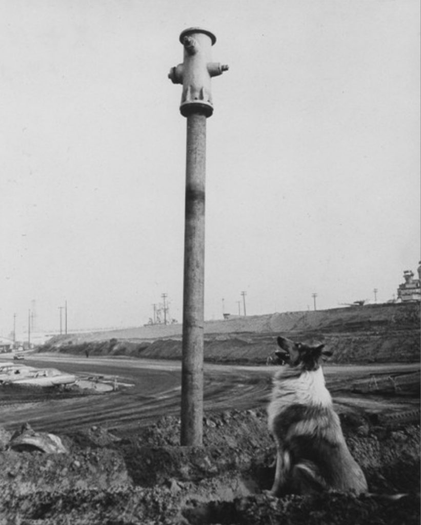
THUMS Long Beach CA sinking image

The prospering but “sinking city” of Long Beach would solve its subsidence problem with four islands and advanced drilling and production technologies. Photo by Roger Coar, 1959, courtesy Long Beach Historical Society.

To counter subsidence, five 1,750-horsepower motors on White Island drive water injection pumps to offset extracted petroleum, sustain reservoir pressures, and extend oil recovery. The challenge was once described as “a massive Rubik’s Cube of oil pockets, fault blocks, fluid pressures and piping systems.”

Meanwhile, all of this happens amidst the scenic boating and tourist waters in Long Beach Harbor.

The California Resources Corporation operates the offshore part on the islands of the Wilmington field, the fourth-largest U.S. oilfield, according to the Los Angeles Association of Professional Landmen, whose members toured the facilities in November 2017.

Producing in Plain Sight

“Most interestingly, the islands were designed to blend in with the surrounding coastal environment,” explained LAAPL Education Chair Blake W.E. Barton of Signal Hill Petroleum.

“The drilling rigs and other above-ground equipment are camouflaged and sound-proofed with faux skyscraper skins and waterfalls,” Barton noted.

Most people simply do not realize the islands are petroleum production facilities. From the shore, the man-made islands appear occupied by upscale condos and lush vegetation. Many of the creative disguises came courtesy of Joseph Linesch, a pioneering designer who helped landscape Disneyland.

Support the American Oil & Gas Historical Society

The THUMs islands required exceptional designs, and “the people who were involved at the time were very creative visionaries,” said Frank Komin, executive vice president for southern operations of the California Resources Corporation (CRC), owner of the islands.

About 80 percent of the company’s properties would overlie the Wilmington oilfield, according to CRC, noting that from 2003 to 2018, CRC operations generated over $5.2 billion in revenues, taxes and fees for the City of Long Beach and the state.
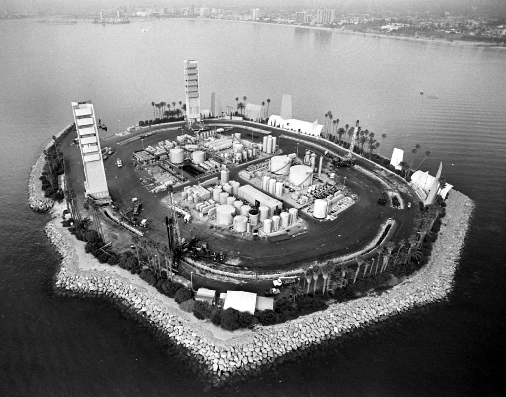
THUMS oil platorms picture from above

THUMS Island White, named for Col. Edward White II, the first American to walk in space, who died in 1967 along with NASA astronauts “Gus” Grissom and Roger B. Chaffee. A fourth island was named for NASA test pilot Ted Freeman, who in 1963 was the first fatality among the astronauts. Photo courtesy UCLA Library.

“Even today, those islands are viewed as one of the most innovative oil field designs in the world,” CRC executive Komin declared in a 2015 Long Beach Business Journal article. “The islands have grown to become icons in which the City of Long Beach takes a great deal of pride.” 

The Journal explained that 640,000 tons of boulders, some as large as five tons, were mined and placed to build up the perimeters of the islands. “Concrete facades constructed for aesthetic purposes also divert industrial noise away from nearby residents,” the article added.  For more noise abatement, electricity has provided nearly all the power for the islands.

Support the American Oil & Gas Historical Society

The THUMS aesthetic integration of 175-foot derricks and production structures has been described by the Los Angeles Times as, “part Disney, part Jetsons, part Swiss Family Robinson.”

_______________________

Recommended Reading: An Ocean of Oil: A Century of Political Struggle over Petroleum Off the California Coast (1998); Black Gold in California: The Story of California Petroleum Industry (2016); Early California Oil: A Photographic History, 1865-1940 (1985). Your Amazon purchases benefit the American Oil & Gas Historical Society. As an Amazon Associate, AOGHS earns a commission from qualifying purchases.

_______________________

The American Oil & Gas Historical Society (AOGHS) preserves U.S. petroleum history. Become an AOGHS annual supporting member and help maintain this energy education website and expand historical research. For more information, contact bawells@aoghs.org. Copyright © 2023 Bruce A. Wells. All rights reserved.

Citation Information – Article Title: “THUMS – California’s Hidden Oil Islands.” Authors: B.A. Wells and K.L. Wells. Website Name: American Oil & Gas Historical Society. URL: https://aoghs.org/technology/thums-california-hidden-oil-islands. Last Updated: February 23, 2024. Original Published Date: March 8, 2018.

Pin It on Pinterest