by Bruce Wells | Apr 2, 2026 | Petroleum Pioneers
As drillers and speculators rushed to Spindletop Hill, the Texas Company was organized in 1902.
A series of oil and natural gas discoveries at Sour Lake, Texas — near the famous 1901 gusher at Beaumont — helped launch the major oil company Texaco.
Originally known as Sour Lake Springs because of sulfurous spring water popular for its healing properties, a series of oil discoveries brought wealth and new petroleum companies to Hardin County in southeastern Texas.
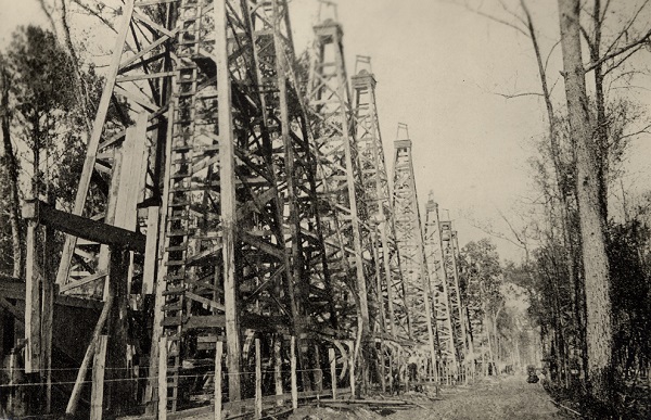
“A forest of oil well derricks at Sour Lake, Texas,” circa early1900s, courtesy the W.D. Hornaday Collection, Texas State Library and Archives Commission, Austin. Oil discoveries at the resort town northwest of the world-famous 1901 Spindletop gusher transformed the Texas Company into Texaco.
As the science of petroleum exploration and production evolved, some geologists predicted oil was trapped at a salt dome at Sour Lake, similar to that of Beaumont’s Spindletop Hill formation, which was producing massive amounts of oil.
According to Charles Warner in Texas Oil & Gas Since 1543, in November 1901 an exploratory well found “hot salt water impregnated with sulfur between 800 and 850 feet…and four oil sands about 10 feet thick at a depth of approximately 1,040 feet.”
Warner noted that the Sour Lake Springs field’s discovery well came four months later when a second attempt by the Great Western Company drilled “north of the old hotel building” in the vicinity of earlier shallow wells.

“This monument marks the site of the Texas Company’s first producing oil well.” The Fee No. 3 well flowed at 5,000 barrels of oil a day in 1903, launching the Texas Company into becoming Texaco.
“This well secured gusher production at a depth of approximately 683 feet on March 7, 1902,” Warner reported. “The well penetrated 40 feet of oil sand. The flow of oil was accompanied by a considerable amount of loose sand, and it was necessary to close the well in from time to time and bail out the sand, after which the well would respond with excellent flows.”
As more discoveries followed, Joseph “Buckskin Joe” Cullinan and Arnold Schlaet were among those who rushed to the area from their offices in Beaumont.
“Buckskin Joe” Cullinan
The most significant company that started during the Spindletop oil boom was The Texas Company, according to historian Elton Gish.

“Cullinan worked in the Pennsylvania oil industry and later went to Corsicana, Texas, about 1898 when oil was first discovered in that district, where he became the most prosperous operator in the field,” reported Gish in his “History of the Texas Company and Port Arthur Works Refinery.”
Cullinan formed the Petroleum Iron Works, building oil storage tanks in the Beaumont area — where he was introduced to Schlaet. “When the Spindletop boom came in January 1901, Mr. Cullinan decided to visit Beaumont,” Gish noted. Schlaet managed the oil business of two brothers, New York leather merchants.
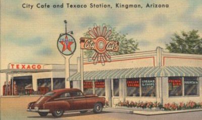
Named after its New York City telegraph address, the Texaco brand became official in 1959. Postcard of a Texaco service station next to a cafe in Kingman, Arizona.
“Schlaet’s field superintendent, Charles Miller, traveled to Beaumont in 1901 to witness the Spindletop activity and met with Cullinan, whom he knew from the oil business in Pennsylvania. He liked Cullinan’s plans and asked Schlaet to join them in Beaumont.”
According to Texaco, Cullinan and Schlaet formed the Texas Company on April 7, 1902, by absorbing the Texas Fuel Company and inheriting its office in Beaumont. Texas Fuel had organized just one year earlier to purchase Spindletop oil, develop storage and transportation networks, and sell the oil to northern refineries.

By November 1902, the new Texas Company was establishing a new refinery in Port Arthur as well as 20 storage tanks, building its first marine vessel, and equipping an oil terminal to serve sugar plantations along the Mississippi River.
Fee No. 3 Discovery
The Texas Company struck oil at Sour Lake Springs in January 1903, “after gambling its future on the site’s drilling rights,” the company explained. “The discovery, during a heavy downpour near Sour Lake’s mineral springs, turned the company into a major oil producer overnight, validating the risk-taking insight of company co-founder J.S. Cullinan and the ability of driller Walter Sharp.”
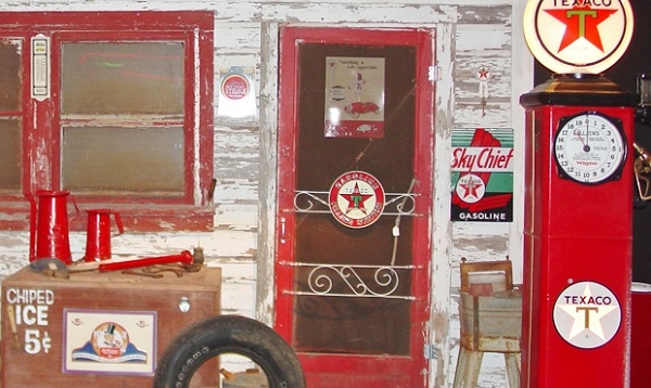
A Texaco station was among the 2012 indoor exhibits featured at the National Route 66 Museum in Elk City, Oklahoma. Photo by Bruce Wells.
Their 1903 Hardin County discovery at Sour Lake Springs — the Fee No. 3 well — flowed at 5,000 barrels a day, securing the Texas Company’s success in petroleum exploration, production, transportation, and refining. Sharp founded the Sharp-Hughes Tool Company in 1908 with Howard Hughes Sr.
High oil production levels from the Sour Lake field and other successful wells in the Humble oilfield (1905) secured the company’s financial base, according to L. W. Kemp and Cherie Voris in the Handbook of Texas Online.
“In 1905 the Texas Company linked these two fields by pipelines to Port Arthur, ninety miles away, and built its first refinery there. That same year the company acquired an asphalt refinery at nearby Port Neches,” the authors noted.
“In 1908 the company completed the ambitious venture of a pipeline from the Glenn Pool, in the Indian Territory (now Oklahoma), to its Southeast Texas refineries,” added Kemp and Voris.
Telegraph Address: Texaco
As early as 1905, the Texas Company had established marketing facilities not only throughout the United States but also in Belgium, Luxembourg, and Panama.
The Texas Company registered “Texaco” as a trademark in 1909.
The telegraph address for the company’s New York office is “Texaco” — a name soon applied to its products. The company registered its first trademark, the original red star with a green capital letter “T” superimposed on it in 1909. The letter remained an essential component of the logo for decades.
In August 1926, the Texas Corporation incorporated in Delaware (from Texas) and by an exchange of shares acquired outstanding stock of The Texas Company, which was dissolved the next year.
The new corporation became the parent company of numerous “Texas Company” — Texaco — entities and other subsidiaries, according to Jim Hinds of Columbus, Indiana (see Histories of Indian Refining, Havoline, and Texaco). By 1928, Texaco operated more than 4,000 gasoline stations in 48 states. It already was a major oil company when it officially renamed itself Texaco in 1959.
1987 Bankruptcy
Texaco lost a 1985 court battle following its purchase of Getty Oil Company. In February 1987 a Texas court upheld the decision against Texaco for having initiated an illegal takeover of Getty Oil after Pennzoil had made a bid for the company. Texaco filed for bankruptcy in April 1987.
The companies settled their historic $10.3 billion legal battle for $3 billion when Pennzoil agreed to drop its demand for interest. The Los Angeles Times reported the compromise was vital for Texaco emerging from bankruptcy, a haven sought to stop Pennzoil from enforcing the largest court judgment ever awarded at the time.

On October 9, 2001, Chevron and Texaco agreed to a merger that created ChevronTexaco — renamed Chevron in 2005. Although the Sour Lake Springs oil boom was surpassed by other Texas discoveries, it has remained the birthplace of Texaco.
Learn more about southeastern Texas petroleum history in Spindletop creates Modern Petroleum Industry and Prophet of Spindletop.
_______________________
Recommended Reading: The Texaco Story, The First Fifty Years 1902 – 1952 by Texas Company (1952). Texaco’s Port Arthur Works, A Legacy of Spindletop and Sour Lake (2003); Giant Under the Hill: A History of the Spindletop Oil Discovery (2008). Your Amazon purchase benefits the American Oil & Gas Historical Society. As an Amazon Associate, AOGHS earns a commission from qualifying purchases.
_______________________
The American Oil & Gas Historical Society (AOGHS) preserves U.S. petroleum history. Please support AOGHS to help maintain this energy education website, a monthly email newsletter, This Week in Oil and Gas History News, and expand historical research. Contact bawells@aoghs.org. Copyright © 2026 Bruce A. Wells.
Citation Information – Article Title: “Sour Lake produces Texaco.” Authors: B.A. Wells and K.L. Wells. Website Name: American Oil & Gas Historical Society. URL: https://aoghs.org/petroleum-pioneers/sour-lake-produces-texaco. Last Updated: April 6, 2026. Original Published Date: April 5, 2014.
by Bruce Wells | Mar 29, 2026 | Petroleum Pioneers
Drilling of a remote wildcat well began in late 1950. The blizzard came in January.
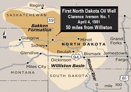
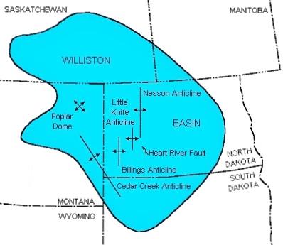
Drillers of a remote wildcat well in Clarence Iverson’s wheat field northeast of Williston endured a North Dakota winter before finding oil in the spring of 1951. Their discovery launched the Williston Basin drilling boom.
At about one in the morning on April 4, 1951, after four months of hard drilling and with snow piled high from recent blizzards, the Clarence Iverson No. 1 well produced oil. Amerada Petroleum’s 1951 discovery — the first commercial oil well in North Dakota — would reveal a prolific petroleum basin stretching from North and South Dakota, Montana, and into Canada.
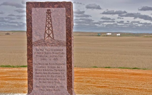
A 1953 marker commemorates the Clarence Iverson No. 1 well, which two years earlier revealed the 134,000-square-mile Williston Basin.
After decades of dry holes drilled from one corner of North Dakota to the other, new technologies and true tool-pusher grit brought the state’s first oil discovery. The headline on the front page of The Minot Daily News on April 5 read, “It’s Official Oil Found At Tioga.”
Although this wildcat drilling attempt had been regarded with great skepticism, within two months of the strike, 30 million acres were under lease. A 2008 article in the Bismarck Tribune, quoted Sid Anderson, the former state geologist, who was a college student at the University of North Dakota when oil was discovered.
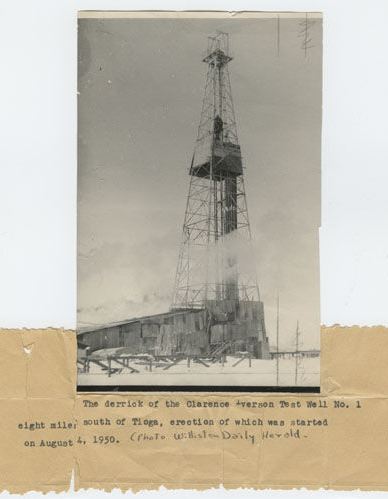
A Williston Daily World photo shows a snowed-in Clarence Iverson No. 1 rig eight miles south of Tioga. Drilling had begun August 4, 1950. Image courtesy State Historical Society of North Dakota.
“It was brand new, then, and pretty exciting times,” Anderson recalled. The amber-colored oil in the area was of such high quality, “you could have run a diesel with it straight from the well.”
“This was the first major discovery in a new geologic basin since before World War II,” James Key declared in Word and Picture Story of Williston and Area.
By 1952, Standard Oil of Indiana was building a 30,000 barrel-per-day refinery, he notes. Forty-two oilfield service and supply companies had opened offices in Williston. In June, Service Pipeline Company announced it would build a pipeline to the Standard refinery.
A U.S. Bureau of Land Management map illustrates the Bakken Shale Formation and the Williston Basin.
Key added that although the Williston Basin is named after the city of Williston, it was first exposed in 1912 by Dr. W.T. Thom Jr., “a sophomore studying geology when he happened into a creek bed in the area of the Cannonball River. It was his discovery of coral that led him to believe that the area was once inundated by an ancient sea.”
On June 17, 2014, North Dakota oil production surpassed one million barrels per day thanks to development of the Bakken shale formation in the western part of the state.
State officials reported North Dakota produced 1,001,149 barrels of oil a day from a record 10,658 wells. Industry journalists, proclaiming the milestone a sign America was freeing itself from foreign oil, referred to the state as “Saudi Dakota.”
North Dakota Dry Holes
The earliest permit issued for oil exploration in North Dakota came from the state geologist in 1923. By the late 1930s, petroleum companies were working with a growing North Dakota Geological Survey to improve the science behind exploration, which often featured difficult formations, including granite, thwarting drilling technologies of the day.
According to historian Clarence Herz, despite repeated failures, companies continued to come to North Dakota and spend large amounts of money on leases and drilling. “There were no indications from any of the wells they drilled that they were even close to production, but that did not deter them,” said Herz, adding that the expensive lessons brought many positive developments.
“A more skilled labor force and continuous technological innovation that included the use of explosives, acid and newly invented scientific instruments meant an acceleration of the drilling process as wells were not only being drilled faster, but deeper and at a much higher cost,” Herz explained.
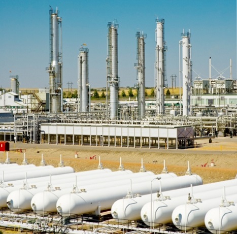
The 1951 well that launched North Dakota’s first oil boom was drilled by Amerada Petroleum. Today, a gas processing plant operates not far from the discovery well northeast of Williston.
One such invention came from two Frenchmen, Conrad and Marcel Schlumberger,” he added. “Schlumberger was fast becoming a household name in the oil industry for the development of an electrical resistivity well log created by the French brothers in 1927.
Although it failed to find oil in the 1930s, the California Oil Company used technological and scientific breakthroughs like rotary drilling and seismometers to reach a depth previously unheard of in the state. A well spudded in October 1937 had to be abandoned in August 1938 when the drill pipe twisted off in the hole almost two miles deep. Attempts to “fish” the pipe failed.
California Oil Company’s failure did not stop exploration in other areas of the state, Herz said, citing a report noting that most major oil companies sent men to North Dakota to investigate — and buy leases. It took the Carter Oil Company three months with modern equipment to drill nearly 5,000 feet in 1940 without finding oil. Two years later the company still had not found it.
Following World War II, Herz noted that “from one corner of the state to the other, companies leap-frogged one another in anticipation of being the first to identify an oil producing zone.”
Leasing about 1.5 million acres, Continental Oil Company worked with the Pure Oil Company trying to find a North Dakota oilfield in the spring of 1949. In September 1950, Magnolia Petroleum became the latest company to drill a North Dakota dry hole.
The Magnolia wildcat well reached a depth of 5,556 feet, found granite, and was plugged and abandoned. Soon others came to North Dakota with large drilling rigs.
1951 Discovery Well
Despite exploration costs, the dry holes were not looked at as failures but as learning experiences with valuable geologic and technical knowledge gained from each attempt.
An independent oilman and investor, Thomas W. Leach was a former chief geologist for an Oklahoma oil company who was convinced oil could be found. In the late 1930s, he had convinced Standard Oil Company of California to drill a well that reached a depth of 10,281 feet.
The site Leach suggested did not find any oil — costing Standard Oil almost a million dollars.
In 1950, geologist Thomas W. Leach convinced Amerada Petroleum of Tulsa that oil could be found in North Dakota’s Nesson Anticline.
After World War II, where he served as a captain of U.S. Army artillery, Leach returned to North Dakota and continued leasing land. The geologist eventually convinced Amerada Petroleum of Tulsa that success could be found in the Nesson Anticline about 50 miles northeast of Williston.
A site was selected on Clarence Iverson’s family farm near Tioga, and drilling began on September 3, 1950, Herz reported. There was little to report until January 1951, “except the depth of the bit, the conditioning of the mud, and the occasional tripping pipe.”
Following a January 29 blizzard that shut down the well, drilling continued until total depth — 11,744 feet — was reached on February 4, 1951. No oil was found. It was decided to try “shooting” the well.
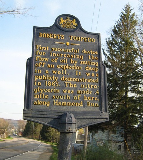
A Pennsylvania historical marker commemorates invention of the earliest perforating technology.
“The practice of perforating a well, or using explosives to perforate the rock, is not new,” says Herz. Colonel Edward A. L. Roberts first used his “Roberts Torpedo” in 1865. The practice was successful, and soon the dry holes of Pennsylvania were turned into producers by blasting wells with nitroglycerin torpedoes (see Shooters — A “Fracking” History).
Advancements to improve oil and natural gas production came from the invention of a Downhole Bazooka to perforate well casings. Perforation became a standard practice whereby multiple charges attached to a gun were lowered into the well’s casing. Once in place the charges were fired, perforating the well at small intervals, hopefully releasing the oil from the rock.
Perforating the Well
The Clarence Iverson No. 1 well was “shot” from 11,706 feet to 11,729 feet using a Lane-Wells Company “Koneshot,” but still no oil was found. “The Koneshot was a type of perforating gun that used a shaped charge. It was another innovation,” Herz explained. He added that charges had “a spiral placement in a steel housing at a three-inch centerline distance from each other.”
The arrangement was an improvement over some of the early perforators (learn more about perforating with shaped charges in Downhole Bazooka).
Work on the Iverson well was again halted the week of March 5 by another blizzard. The well would remain idle for several weeks until the snow-choked roads could be cleared for passage. With the well plugged back to a depth of 11,669 feet, the work stopped to make repairs and prepare for another perforation.

Cliff Iverson stands by a monument on the family farm in Tioga, North Dakota, in August 2008. The monument marks the April 4, 1951, oil discovery on his late father’s farm.
The well was again perforated, this time from 11,630 feet to 11,640 feet with four holes per foot. At 12:55 a.m. on April 4, 1951, the Clarence Iverson No. 1 began producing about 240 barrels of oil a day. The state of North Dakota finally had its first discovery well.
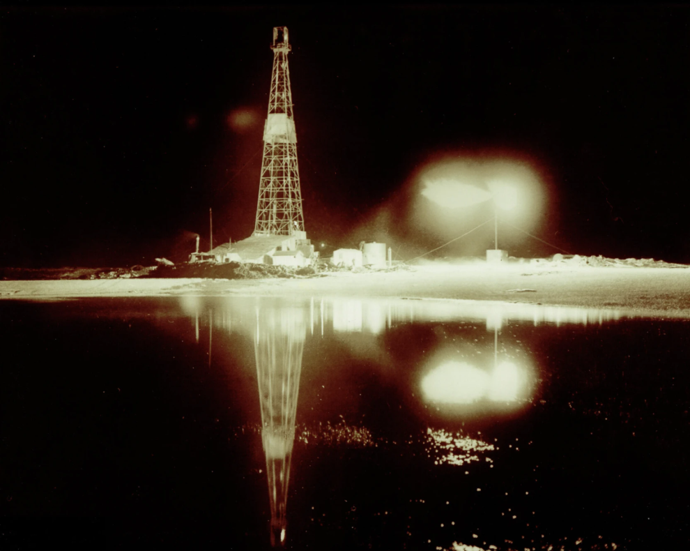
The Clarence Iverson No. 1 well — the fist well in North Dakota to produce petroleum — on the night of April 4, 1951. Photo courtesy of State Historical Society of North Dakota.
According to a 2008 Associated Press article, at first Clarence Iverson wasn’t pleased when seismologists exploded dynamite in his wheat fields looking for oil. His son Cliff, who was 20 when oil was found on the family farm, remembers his father smiling when oil surfaced.
“He worried a lot about his water wells,” Cliff said of his father. The farm became one of the biggest tourist attractions in the Upper Midwest after oil was discovered there. “They came from as far as Minnesota and all over North Dakota and Montana,” he added. “People knew it was history in the making, and it changed a lot of people’s lives.”
On April 5, 1951, the front-page headline of The Minot Daily News read, “It’s Official Oil Found At Tioga.” The newspaper returned to the story in 2026 for a 75th anniversary article, and quoting from its 1951 reporting on the well “that propelled North Dakota into the ranks of oil producing states.”
The Clarence Iverson No. 1 well alone produced 585,000 barrels of oil. Clarence Iverson, who died in 1986, reportedly never got used to all that money.
The Bakken Shale
The earliest producing wells of the Bakken shale formation were drilled in the early 1950s on Henry O. Bakken’s farm less than five miles from the Clarence Iverson No. 1 well. Occupying about 200,000 square miles within the Williston Basin, the oil shale of the Bakken formation may be the largest domestic oil resource since Alaska’s Prudhoe Bay, according to many experts. But efforts to extract shale oil using conventional vertical wells proved difficult.
“The Clarence Iverson well produced from the Silurian, Duperow, and Madison formations, but not the Bakken,” reported Kathy Neset, a geologist who moved to Tioga from New Jersey in 1979. “There are several oil-producing formations at different depths within the larger Williston Basin.”

The Bakken shale play consists of three layers, according to the Energy Policy Research Foundation, Inc. The middle sandstone layer is what is commonly drilled and fractured.
The Bakken formation frustrated a lot of geologists for years, “because they knew the oil was there, but they didn’t have the technology to extract the oil,” Neset explained in a 2012 Mitchell Republic newspaper article, “Famous Bakken Formation Named For North Dakota Homesteaders.”
The Bakken formation first produced in 1953 from a well named after Henry Bakken, the landowner. Like the Williston discovery well, it was also drilled by Amerada Petroleum. This first shale well was on the Nesson Anticline, later known as a Bakken “sweet spot,” home to natural fractures in the rock, according to the Energy Policy Research Foundation.
Although North Dakota has been an oil-producing state since 1951, only during the past decade has the Bakken oil boom made it the fourth largest producing state — and one of the largest onshore plays in the entire United States.
“The Bakken is a shale oil play. It is conventional, light-sweet crude oil, trapped 10,000 feet below the surface within shale rock,” the foundation noted (also see Ute Oil Company — Oil Shale Pioneers). The shale consists of three layers — an upper layer of shale rock, a middle layer of sandstone/dolomite, and a lower layer of shale rock. The middle sandstone layer is what is commonly drilled and fractured.
“Production was mainly from a few vertical wells — until the 1980s when horizontal technology became available,” added a 2008 article in the Oil Drum. “Only recently after the intensive application of horizontal wells combined with hydraulic fracturing technology did production really take off.”
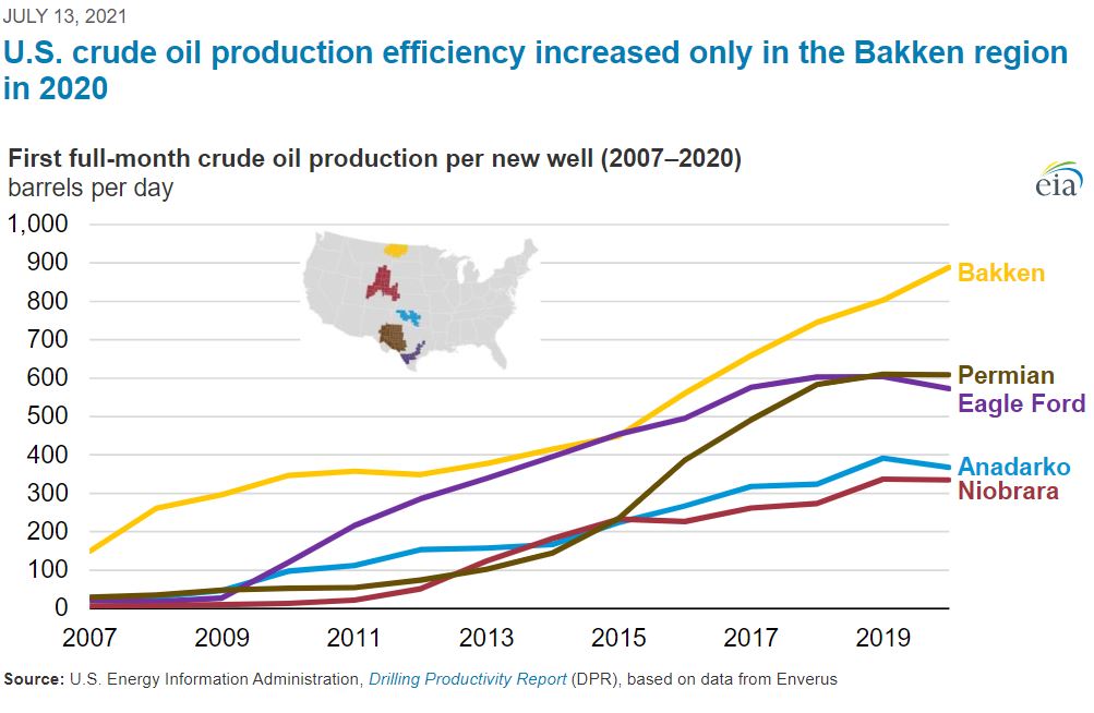
Well production efficiency in the Bakken region increased significantly in 2020, according to the Energy Information Administration (EIA).
U.S. Geological Survey (USGS) in 2008 estimated 3.0 billion barrels to 4.3 billion barrels of undiscovered oil in America’s portion of the Bakken formation, elevating it to a “world-class” accumulation. The survey’s assessment of the shale’s potential was a 25-fold increase in the amount of “technically recoverable” oil compared to the agency’s 1995 estimate of just 151 million barrels of oil.
According to state statistics from 2010, oil production from the Bakken in North Dakota had steadily increased from about 28 million barrels in 2008 to 50 million barrels in 2009 to approximately 86 million barrels. In 2020, initial oil production per well — well production efficiency — increased significantly in the Bakken region, according to the Energy Information Administration (EIA).
A USGS estimate for the Bakken and Three Forks Formations in the Williston Basin of Montana and North Dakota includes 4.3 billion barrels of unconventional oil and 4.9 trillion cubic feet of unconventional natural gas in the two formations.
As Secretary of the Interior Ken Salaza earlier predicted, “The Bakken formation is producing an ever-increasing amount of oil for domestic consumption while providing increasing royalty revenues to American Indian tribes and individual Indian mineral owners in North Dakota and Montana.”
Discover more articles featuring America’s first oil discoveries.
_______________________
Recommended Reading: The Bakken Goes Boom: Oil and the Changing Geographies of Western North Dakota (2016); Trek of the Oil Finders: A History of Exploration for Petroleum (1975). Your Amazon purchases benefit the American Oil & Gas Historical Society; as an Amazon Associate, AOGHS earns a commission from qualifying purchases.
_______________________
The American Oil & Gas Historical Society (AOGHS) preserves U.S. petroleum history. Please support this energy education website, subscribe to our monthly email newsletter, and help expand historical research. Contact bawells@aoghs.org. Copyright © 2026 Bruce A. Wells.
Citation Information – Article Title: “First North Dakota Oil Well.” Authors: B.A. Wells and K.L. Wells. Website Name: American Oil & Gas Historical Society. URL: https://aoghs.org/petroleum-pioneers/north-dakota-williston-basin. Last Updated: April 14, 2026. Original Published Date: March 31, 2014.