Cartographer visited petroleum boom towns to draw popular bird’s-eye views.
Thaddeus M. Fowler created detailed, panoramic maps of America’s earliest petroleum boom towns during the late nineteenth and early twentieth centuries. His popular cartographic depictions of oil patch communities in Pennsylvania, Oklahoma, and Texas offered “aero views” seemingly drawn from great heights.

More than 400 Thaddeus Fowler panoramas have been identified. There are 324 in the Library of Congress, including this one of Oil City, Pennsylvania, in 1896. Source: Library of Congress Geography and Map Division, Washington, D.C.
Fowler has the largest number of panoramic maps in the collection of the Library of Congress (LOC) in Washington, D.C. His hand-drawn lithographs have fascinated viewers since the Victorian Age. Being depicted in one of Fowler’s maps, also known as “bird’s-eye views,” was a matter of civic pride for many community leaders.
Chasing Oil Booms
Thaddeus Mortimer Fowler was born in Lowell, Massachusetts, on December 21, 1842. He served in the 21st New York Volunteers in 1861 and was wounded at the Second Battle of Bull Run a year later before being discharged at Boston in 1863. After the war, Fowler migrated to Wisconsin, where he established his own panoramic map-making company.

An 1896 Fowler panorama of Titusville, Pennsylvania, where Edwin L. Drake launched the U.S. petroleum Industry in August 1859.
Fowler began producing views of Wisconsin and Ohio towns in 1870, the same year Standard Oil Company was incorporated in Ohio.
A panoramic map of Stewart, Ohio, that appeared in surveys by D. J. Lake in the Atlas of Athens County of 1875 became the earliest Fowler map in the LOC collection of American Panoramic Artists.
 In 1885, Fowler moved with his family to Morrisville, Pennsylvania, where he maintained his headquarters for 25 years as he traveled the country.
Morrisville served as Fowler’s home base as he began to draw and publish views of Pennsylvania, West Virginia, and Ohio cities — including oil and natural gas boom towns.
Fowler drew and sold more Pennsylvania panoramas than any other artist. In the LOC collection alone, there are 220 separate Fowler views of the Keystone State.

Viewed from the north looking south, Thaddeus Fowler depicted Wichita Falls, Texas, population of 1,978, probably in the fall of 1890. For a suitable fee, the artist included homes and business as insets. Source: University of Texas at Arlington Library.
An additional 165 Fowler views of Pennsylvania towns are in the Pennsylvania State Archives and at Pennsylvania State University. He also visited the booming oilfield communities in Oklahoma and Texas.
“Thaddeus Mortimer Fowler (1842–1922) was perhaps the most prolific of the dozens of bird’s-eye view artists who crisscrossed the country during the latter three decades of the nineteenth century,” explained the Amon Carter Museum of American Art in 2005.
Fowler produced at least 17 views of different Texas cities in 1890 and 1891, “but that output is dwarfed by his production of almost 250 views of Pennsylvania between 1872 and 1922,” noted the museum.
Oil Town Lithographs
Historians have identified 411 separate Fowler panoramas. “His views of Pennsylvania towns suggest he concentrated on a specific geographical area in a given year, very likely to minimize transportation problems,” according to the LOC.

T.M. Fowler’s 1896 map of Sistersville, West Virginia. An oil discovery four years earlier had revealed a giant oilfield, which transformed this Ohio River community.
From 1895 to 1897, Fowler worked in the western part of Pennsylvania, especially around Pittsburgh. In 1898 and 1899, he sketched West Virginia towns, and from 1900 to 1903, he was back in Pennsylvania. He would travel to Tulsa, Oklahoma, to produce a 1918 map of the “Oil Capital of the World.”

An August 11, 1891, discovery well made Sistersville the world’s leading oil producer. The well was restored as a tourist attraction in 1911 by Quaker State Refining Corporation.
Fowler gained commissions for city plans by interesting citizens and civic groups in the idea of a panoramic map of their community. After one town had agreed to having a map made, he would seek to involve neighboring communities.
By noting that he had already secured an agreement for a view from one town in the area, Fowler would play on the pride, community spirit, and sense of competition of adjacent communities.

Oil derricks are among the many details Fowler included in his Sistersville panorama.
How did Fowler create his maps? Preparation of panoramic maps “involved a vast amount of painstakingly detailed labor,” explains an LOC article on panoramic mapping:
For each project a frame or projection was developed, showing in perspective the pattern of streets. The artist then walked in the street, sketching buildings, trees, and other features to present a complete and accurate landscape as though seen from an elevation of 2,000 to 3,000 feet. These data were entered on the frame in his workroom…A careful perspective, which required a surface of three hundred square feet, was then erected from a correct survey of the city.

This Fowler print of Tulsa, Oklahoma, was published in 1918 — when Tulsa was known as the “Oil Capital of the World” following discovery of the Glenn Pool oilfield on November 22, 1905, four miles south.
Victorian Age Fad
The “bird’s-eye” or “aero” views fascinated the public of America’s Victorian Age. Advances in lithography made inexpensive and multiple copies possible, adds the LOC article.
The citizen could view with pride his immediate environment and point out his own property to guests, since the map artist, for a suitable fee, obligingly included illustrations of private homes as insets to the main city plan. As late as the 1920s, panoramic maps were still in vogue commercially.
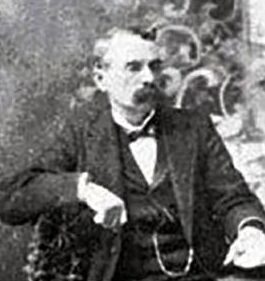
Bird’s-eye-view map artist Thaddeus Mortimer Fowler, 1842-1922.
Thaddeus Mortimer Fowler died in March 1922 in his eightieth year — following a fall on icy streets incurred while preparing a panorama of Middletown, New York.
Panoramic maps of American communities – including petroleum boom towns — preserve a pictorial record of urban life at the time. The artwork documents with historic significance: For some communities, Fowler “aero views” are the only early maps that have survived.
_______________________
Recommended Reading: Bird’s Eye Views: Historic Lithographs of North American Cities


_______________________
The American Oil & Gas Historical Society (AOGHS) preserves U.S. petroleum history. Support this energy education website with an annual contribution today. For membership information, contact bawells@aoghs.org. © 2023 Bruce A. Wells.
Citation Information – Article Title: “Oil Town Aero Views.” Authors: B.A. Wells and K.L. Wells. Website Name: American Oil & Gas Historical Society. URL: https://aoghs.org/petroleum-art/oil-town-aero-views. Last Updated: December 15, 2023. Original Published Date: June 1, 2004.